Volcanic arcs are chains of volcanoes that form above a subducting slab, for example, the Cascades in the Pacific Northwest, the Japanese Archipelago, the Aleutian Islands, and parts of the Andes. Volcanic arcs are a result of rising magma produced in the mantle wedge, but the exact mechanisms controlling the arc position are debated. This study led by SWaMMIS collaborators at Imperial College London finds that the cold corner of the mantle wedge plays a key role. Results from kinematically driven 2D thermo-mechanical modelling help constrain the influence of various factors, including subduction velocity, slab dip, slab age, overriding plate thickness and the depth of decoupling between the slab and the overriding plate.
Western Greece hosts one of the world’s more intriguing and complex subduction systems. To the north, the subducting slab is buoyant continental crust; to the south, the subducting slab is denser oceanic crust. This study provides a detailed description of the transition from continental to oceanic subduction using state-of-the-art seismic imaging techniques on a large data set of local earthquakes. The results help us to better understand how and why fluid processes and seismicity change across the region.
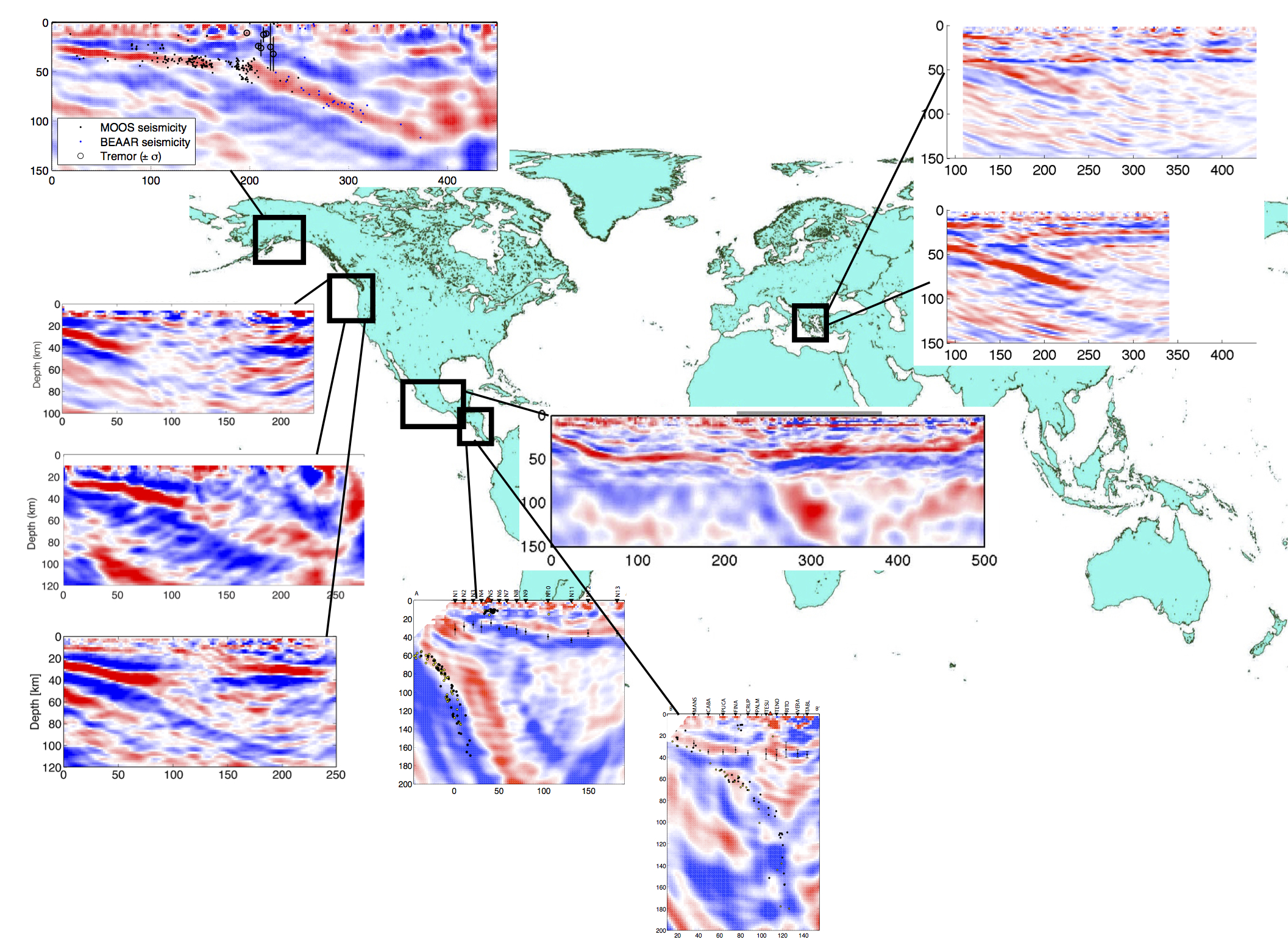
Here is a catalogue of subduction zones worldwide that have been studied using an imaging technique called the 2D Generalized Radon Transform. This technique picks up sharp changes in the propagation speed of teleseismic waves (generated by earthquakes) as they travel through the earth. In the seismic profiles below, the dipping bands of red/blue show the subducting slab as it plunges into the mantle. Subduction zones worldwide exhibit diverse geometries ranging from extremely steep subduction (e.g., Nicaragua and Costa Rica, where the subducting slab is nearly vertical) to rather flat subduction (e.g., Mexico).
Håkon Austrheim leads the SWaMMIS field trips to the world-class outcrops of Holsnøy. Håkon is a professor at the University of Oslo, and a petrologist specializing in fluid-rock interactions and pseudotachylytes.
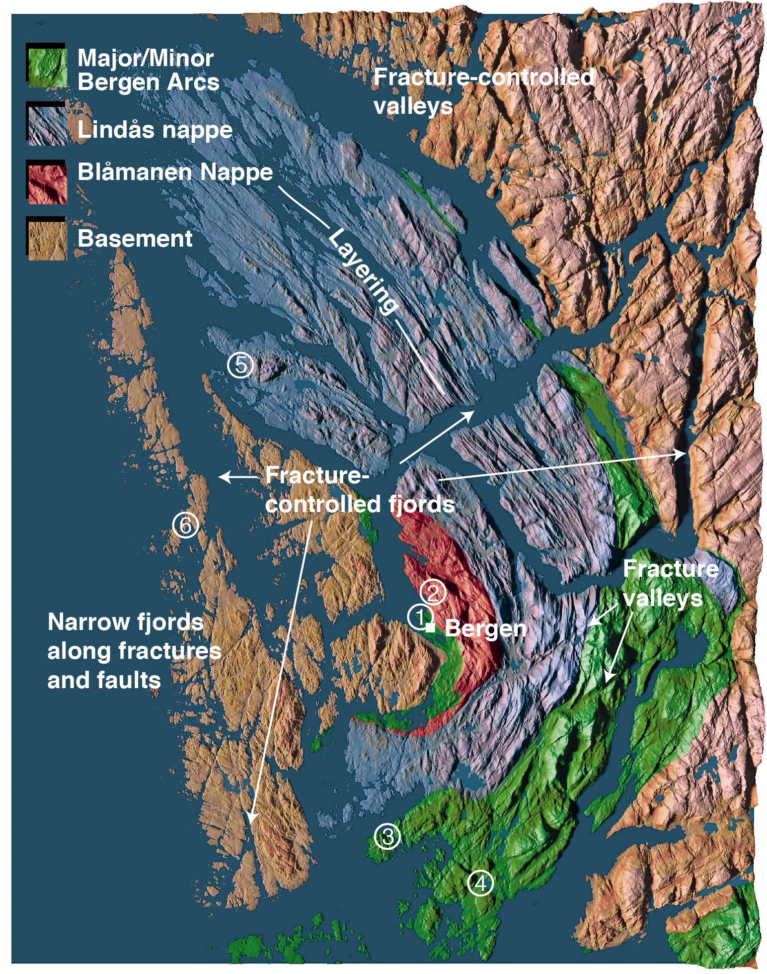
Geologic terranes of the Bergen area. Holsnøy is the island labelled with the number 5, and is part of the Lindås Nappe. Map from the website of Håkon Fossen; see his excellent page on the Bergen Arcs System for more information.
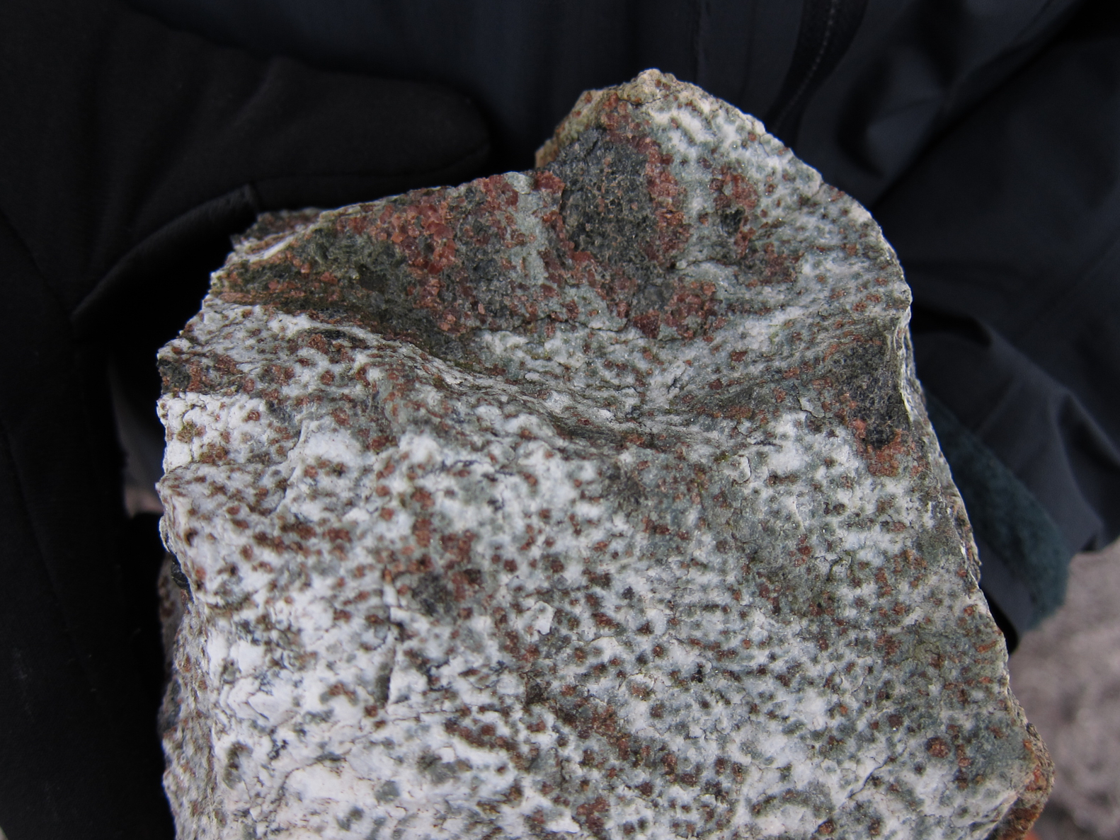
The outcrops on Holsnøy reveal the complexity of rock reactions in the deep continental crust. During the Caledonian Orogeny (400 to 450 million years ago), these rocks were 60 km down at the base of an ancient mountain belt, where the pressure-temperature conditions would be expected to transform granulite facies rocks into ecologites. However, the outcrops we see at the surface today contain both types of rock — white-grey granulite and dark green ecologite. Why is this? Because the process of eclogitization not only requires high pressures and temperatures, it also needs water (H2O). H2O can come from hydrous minerals in the rock or from fluids percolating through the rock. The granulite of the Holsnøy outcrops is rather dry, and thus ecologitization occurred only where it came in contact with aqueous fluids.
Granulite (white) and ecologite (dark green) with red-brown garnets.
Pseudotachylytes (locally molten rock, quickly cooled as amorphous glass) within some outcrops on Holsnøy are evidence of earthquakes at the base of the Caledonides mountain belt, at depths far deeper than where one would normally expect earthquakes according to the brittle-ductile transition (usually around 15 km). Earthquakes deeper than 40 km depth, termed “intermediate depth earthquakes”, are observed today in active subduction zones and at the base of the Himalaya. The mechanism behind intermediate depth earthquakes remains one of the outstanding questions in seismology.
Håkon was one of the first geologists to recognize the field record of deep earthquakes, which led to a number of high-profile publications about the geology in Bergen’s backyard (see, for example, Pseudotachylytes Generated During Seismic Faulting and Eclogitization of the Deep Crust). He has also shaped current ideas that metamorphism cannot be predicted through pressure-temperature conditions alone, but that fluids are usually required to transform an otherwise metastable rock.
How “vein” are rock-stars? This is perhaps one of the most photographed outcrops in the Bergen area. Fluids circulating through this vein transformed the surrounding granulite (grey) into eclogite (green).Blocks of “dry” garnet granulite (anorthosite gabbro) within an eclogitized matrix.
Subduction zone Water and Metamorphism: a Modelling and Imaging Study